The Tide Does Not Negotiate: Britain's Intertidal Planning Crisis and the Battle for a Legal Shoreline
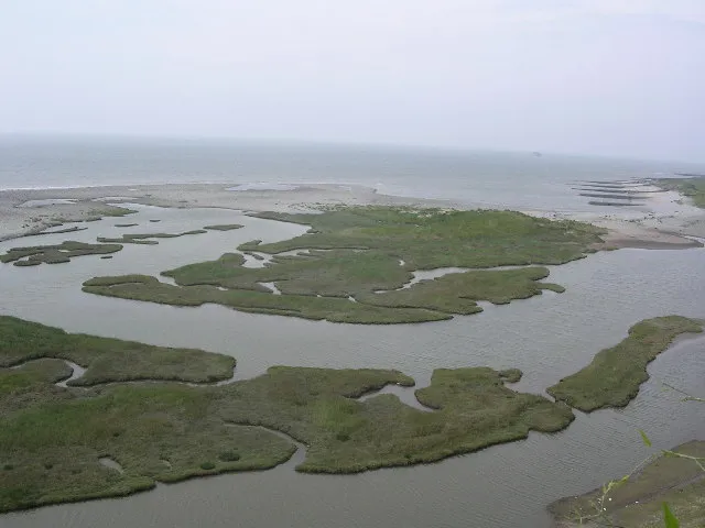
Photo: Jim Mitchell, CC BY-SA 2.0, via Wikimedia Commons
The Tide Does Not Negotiate: Britain's Intertidal Planning Crisis and the Battle for a Legal Shoreline
The foreshore has always been contested ground. In English and Welsh law, the intertidal zone — the land exposed and submerged by the movement of the tides — occupies a peculiar constitutional position. It belongs, in the absence of private title, to the Crown Estate. It is subject to a patchwork of planning legislation, marine licensing requirements, and environmental designations whose jurisdictional boundaries are drawn, in most cases, according to mean low-water marks established by Ordnance Survey during surveys conducted in the nineteenth and early twentieth centuries.
The problem is that the foreshore has not remained where those surveys placed it. Coastal erosion, sediment redistribution, sea-level rise, and the physical consequences of human engineering works have shifted the physical boundary of the intertidal zone in ways that modern LiDAR surveys and hydrographic measurements record with millimetre precision. The statutory definitions that govern planning law, however, have not kept pace. The result is an expanding archipelago of legal grey zones where the land that physically exists and the land that legally exists have quietly parted company.
The Statutory Anachronism
In England and Wales, the boundary between terrestrial and marine planning jurisdiction is drawn at mean high-water mark for most purposes, with the Crown Estate's foreshore interest extending to mean low-water mark. These definitions are embedded in legislation including the Town and Country Planning Act 1990, the Marine and Coastal Access Act 2009, and the Food and Environment Protection Act 1985, among others.
The mean low-water mark, as a legal concept, refers to a position on the shore calculated from tidal predictions and historically fixed by survey. It is not a dynamic line that moves in response to physical change; it is a statutory datum, a line on a map that carries legal weight irrespective of where the water actually retreats to on any given morning.
Modern measurement technology has exposed the gap between that statutory datum and physical reality with uncomfortable clarity. The Environment Agency's national LiDAR programme, combined with the United Kingdom Hydrographic Office's continuous bathymetric survey work, now provides topographic and hydrographic data of sufficient resolution to delineate the intertidal zone with a precision that nineteenth-century triangulation could not approach. Where those modern datasets are overlaid against the statutory mean low-water mark, discrepancies of tens to hundreds of metres are not uncommon along dynamic coastlines.
The Severn Estuary: Where the Gap Is Widest
No stretch of British coastline illustrates the problem more starkly than the Severn Estuary. With a tidal range exceeding fourteen metres — the second highest in the world — the Severn's intertidal zone is vast, mobile, and economically significant. Proposals for tidal energy infrastructure, port expansion, aquaculture developments, and aggregate extraction have repeatedly collided with the question of where, precisely, terrestrial planning law ends and marine licensing begins.
 Photo: Severn Estuary, via base-prod.rspb-prod.magnolia-platform.com
The statutory mean low-water mark along much of the Severn's Welsh and English shores was established during Ordnance Survey resurveys conducted in the mid-twentieth century. In the intervening decades, significant stretches of foreshore have migrated landward or seaward in response to estuary-wide sediment dynamics and the engineering works associated with the Severn crossings. Planning applications for developments in the intertidal zone have been submitted variously to local planning authorities and the Marine Management Organisation, with the choice of regulator influenced in some cases by which jurisdiction the applicant considered more favourable to their proposal.
This regulatory forum-shopping is not illegal — it is a rational response to genuine ambiguity. But it produces outcomes that are inconsistent, difficult to challenge, and occasionally result in permitted development on land whose legal status is, at best, uncertain.
Morecambe Bay: Invisible Land, Contested Claims
Morecambe Bay presents a different dimension of the same problem. The bay's extraordinary shallow gradient means that relatively modest changes in the position of the mean low-water mark translate into large areas of foreshore whose ownership and planning status are genuinely unclear. Several stretches of the bay's intertidal zone have been the subject of competing claims between the Crown Estate, private landowners whose titles reference historic survey datums, and local authorities asserting rights of way over foreshore that has, in physical terms, migrated into what was formerly navigable water.
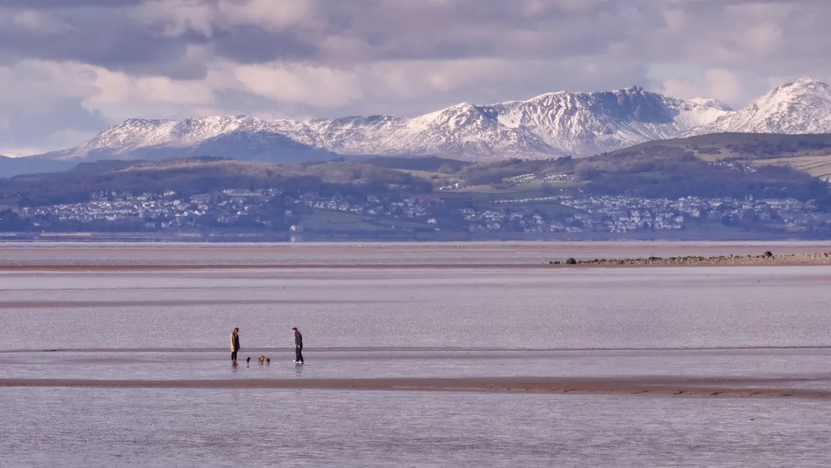 Photo: Morecambe Bay, via www.hawthornscaravanpark.co.uk
The Crown Estate's own geographic information team has acknowledged, in published technical documentation, that its foreshore boundary data in parts of Morecambe Bay is based on surveys that do not reflect current physical conditions. The practical consequence is that the Crown Estate cannot be certain, in some locations, where its legal interest begins and ends — a situation that would be remarkable in any other context of property ownership.
Several development proposals for renewable energy infrastructure within the bay have stalled in pre-application discussions as developers, the Crown Estate, and the Marine Management Organisation have been unable to agree on the applicable planning regime for specific areas of foreshore. The cost of this uncertainty — in professional fees, delayed investment, and deferred clean energy capacity — is significant and entirely avoidable.
The Thames Estuary: Development Pressure in the Grey Zone
Along the Thames Estuary, the intersection of intense development pressure and geographic ambiguity has produced outcomes that merit closer scrutiny. The estuary's intertidal mudflats are both ecologically critical — they support internationally important populations of migratory waders and wildfowl — and coveted by developers seeking waterfront sites in proximity to London.
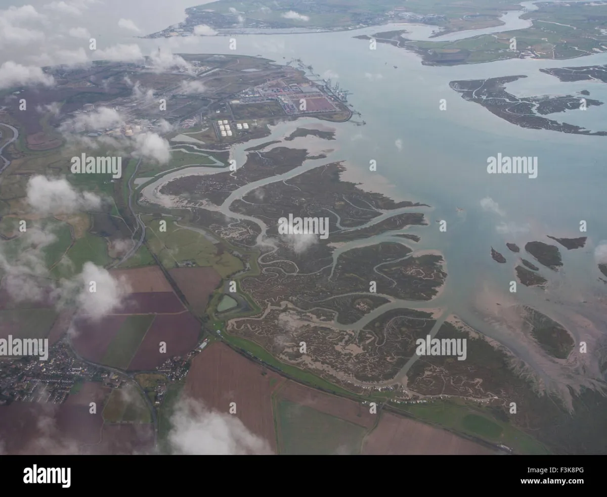 Photo: Thames Estuary, via c8.alamy.com
In several locations between Gravesend and the outer estuary, LiDAR surveys conducted by the Environment Agency reveal that the statutory mean low-water mark, as recorded in planning authority geographic information systems, lies landward of the physical boundary of the intertidal zone as currently measured. In practical terms, this means that strips of mudflat that are legally foreshore — and therefore subject to Crown Estate interest and marine licensing requirements — are being treated by local planning authorities as dry land subject to terrestrial planning consent.
The implications for ecological protection are serious. Intertidal mudflats within the statutory mean low-water mark are subject to a suite of environmental protections, including Ramsar designation and Special Protection Area status under the Conservation of Habitats and Species Regulations 2017. Where the statutory boundary misrepresents the physical extent of the intertidal zone, those protections may not be applied to land that physically qualifies for them.
The Technical Solution That Awaits Political Will
The technical infrastructure required to resolve this crisis largely exists. The Environment Agency's LiDAR archive covers the majority of England's coastline at one-metre resolution or better, with ongoing collection improving coverage and currency. The UK Hydrographic Office maintains continuous bathymetric survey programmes in priority estuaries. Ordnance Survey's coastal change mapping programme tracks shoreline position with a regularity that would support a dynamically updated mean low-water mark dataset.
What does not exist is a mechanism for translating that technical capability into a legally authoritative, dynamically maintained tidal boundary dataset with statutory weight. The Geospatial Commission's remit explicitly encompasses the coordination of national geographic data infrastructure, and the creation of a national dynamic coastal boundary dataset falls squarely within that mandate.
Such a dataset would need to resolve several non-trivial questions: how frequently should the statutory mean low-water mark be updated, and what survey methodology should govern its determination? How should transitional provisions protect existing planning consents and property rights that were granted in good faith under the previous boundary definition? How should the dataset interact with the separate but related question of coastal squeeze and managed realignment under climate adaptation strategies?
These are questions of governance and law as much as geography, and they require a multi-agency response coordinated at ministerial level. The Department for Levelling Up, Housing and Communities, the Marine Management Organisation, the Environment Agency, the Crown Estate, and Ordnance Survey each hold a relevant piece of the puzzle. What is absent is the convening authority to assemble them into a coherent solution.
Conclusion
The tide, as this article's title observes, does not negotiate. It advances and retreats according to celestial mechanics that are entirely indifferent to the administrative convenience of planning legislation drafted in the age of paper surveys. Britain's coastline is physically dynamic in ways that its legal geography refuses to acknowledge, and that refusal is generating real harm — to ecological assets, to investment certainty, to the integrity of the planning system, and ultimately to the communities that depend on a coastline managed in accordance with its physical reality rather than a statutory fiction.
The case for a single, authoritative, dynamically maintained tidal boundary dataset is technically unassailable and practically urgent. The question is whether the political will exists to construct it before the gap between the map and the shore widens beyond the point at which orderly resolution remains possible.