The Disappearing Edge of Britain
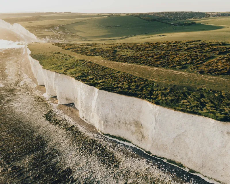
Every year, Britain's coastline retreats inland by an average of two metres, with some locations experiencing losses of up to ten metres annually. Yet the Ordnance Survey's official coastal boundaries, upon which property deeds, insurance policies, and planning permissions depend, are updated on cycles that can span several years. This fundamental mismatch between the pace of physical change and administrative recognition has created a geographic blind spot with profound implications for millions of coastal residents and businesses.
The consequences extend far beyond academic cartography. In Norfolk, entire caravan parks have vanished into the North Sea whilst still appearing on official maps. Property boundaries that once defined beachfront gardens now lie beneath several metres of water, yet Land Registry records remain unchanged. Insurance companies, relying on outdated flood risk models based on historical shoreline positions, are systematically miscalculating exposure to coastal inundation.
The Technology Gap in Coastal Surveillance
Traditional surveying methods cannot match the velocity of coastal change. Annual aerial photography campaigns, the backbone of Britain's mapping infrastructure for decades, provide snapshots rather than the continuous monitoring required for dynamic coastlines. By the time new imagery is processed and integrated into official datasets, the physical reality has already shifted substantially.
Modern geospatial technology offers solutions that could transform coastal monitoring from reactive to predictive. Drone-mounted LiDAR systems can capture centimetre-accurate topographic data at a fraction of the cost of traditional methods. Synthetic Aperture Radar (SAR) satellites provide all-weather monitoring capabilities, detecting coastal changes regardless of cloud cover or lighting conditions. Machine learning algorithms can analyse these data streams to predict erosion patterns with unprecedented accuracy.
However, implementation remains fragmented across Britain's coastal authorities. Whilst some progressive councils have invested in quarterly drone surveys, others continue to rely on mapping data that predates the smartphone era.
Legal Limbo for Coastal Properties
The disconnect between physical reality and legal documentation creates unprecedented challenges for property law. When a property boundary is defined as "extending to the high water mark," but that mark has retreated fifty metres inland, which position takes precedence? Land Registry records, based on historical surveys, may show property extending into areas now permanently submerged.
This ambiguity has spawned a new category of legal disputes. Property owners discover their gardens have legally vanished whilst their mortgage obligations remain intact. Conversely, some properties have gained land through accretion, but these additions remain unrecognised in official records, creating complications for future sales or development applications.
The situation is particularly acute for commercial properties. Coastal hotels, restaurants, and retail establishments face insurance challenges when their actual footprint no longer matches their registered boundaries. Planning applications for coastal defences require accurate baseline measurements, but outdated mapping data can invalidate environmental impact assessments before construction begins.
Infrastructure Planning in a Shifting Landscape
Britain's critical infrastructure increasingly relies on precise geospatial data for long-term planning. The National Grid's coastal substations, railway lines running parallel to eroding cliffs, and coastal sewage treatment facilities all require accurate erosion predictions to inform investment decisions and risk assessments.
Current infrastructure planning typically uses historical erosion rates to project future coastline positions. However, climate change is accelerating coastal erosion beyond historical precedents. Sea level rise, increased storm frequency, and changing precipitation patterns are creating erosion scenarios that have no historical analogue.
Advanced coastal monitoring systems could provide the data foundation for adaptive infrastructure planning. Real-time erosion monitoring would enable proactive rather than reactive responses to coastal change. Infrastructure operators could implement graduated responses based on actual measured retreat rates rather than theoretical projections.
The Economic Cost of Mapping Delays
The financial implications of outdated coastal mapping extend across multiple sectors. Insurance companies face potential claims disputes when policies are based on inaccurate property boundaries. Local authorities struggle to set accurate council tax valuations for properties whose actual extent differs from registered boundaries.
The mortgage market faces particular challenges. Lenders require accurate property valuations, but traditional surveyors often rely on outdated mapping data. Properties may be over-valued if mapping shows land that has already eroded, or under-valued if accretion has increased the actual property size.
Tourism, a vital component of many coastal economies, depends on accurate information about beach access, coastal paths, and recreational facilities. Outdated mapping can direct visitors to locations that no longer exist, whilst new coastal features remain undiscovered due to mapping delays.
Towards Dynamic Coastal Mapping
Britain requires a fundamental shift from periodic coastal surveying to continuous monitoring systems. Integration of multiple data sources—satellite imagery, drone surveys, ground-based sensors, and citizen reporting—could create a living map of Britain's coastline that updates in near real-time.
The technology exists, but implementation requires coordination between the Ordnance Survey, Land Registry, local authorities, and environmental agencies. Standardised data formats and automated processing workflows could ensure that coastal changes are reflected across all relevant datasets within weeks rather than years.
Such systems would transform coastal management from crisis response to predictive planning. Property owners could receive early warnings about boundary changes, infrastructure operators could implement adaptive strategies based on actual erosion rates, and insurance companies could price policies based on current rather than historical risk assessments.
Britain's coastline will continue changing regardless of our mapping capabilities. The question is whether our geographic data systems will evolve to match the pace of physical change, or whether the growing disconnect will continue to undermine effective coastal management and property rights across maritime Britain.