The Hidden Geography of Financial Risk
Beneath Britain's property market lies a cartographic crisis that costs homeowners billions annually. Across England and Wales, approximately 6.8 million properties sit within flood risk zones determined by elevation models that predate the smartphone era. These outdated terrain datasets, some derived from Ordnance Survey maps created in the 1970s, continue to dictate insurance premiums, mortgage availability, and property values despite bearing little resemblance to contemporary landscape reality.
The Environment Agency's current flood risk assessments rely heavily on Digital Terrain Models (DTMs) with resolution limitations that can miss crucial topographical features. A drainage ditch installed in 1995, a new flood defence completed last decade, or subtle elevation changes caused by modern development—none of these risk-altering modifications appear in the foundational datasets that determine whether a property faces 'significant' flood risk.
The LiDAR Revolution Britain Hasn't Embraced
Light Detection and Ranging (LiDAR) technology represents a paradigm shift in terrain mapping accuracy. Where traditional surveying methods might capture elevation points every 50 metres, modern airborne LiDAR systems record precise measurements at sub-metre intervals, creating elevation models accurate to within 15 centimetres vertically.
The Netherlands completed a comprehensive national LiDAR survey by 2012, updating their flood risk models with unprecedented precision. Denmark followed suit, integrating high-resolution elevation data with real-time hydrological monitoring to create dynamic flood risk assessments that adjust seasonally. Britain, despite facing some of Europe's most complex flood challenges, continues to rely on patchwork elevation datasets of varying quality and vintage.
Financial Consequences of Geographic Inaccuracy
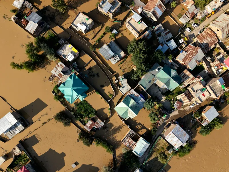
Consider the market town of Tewkesbury, where 2007 floods revealed dramatic discrepancies between predicted and actual inundation patterns. Properties that remained dry despite sitting in 'high risk' zones continue to face inflated insurance premiums, whilst areas that flooded unexpectedly still lack appropriate risk classification. This geographic disconnect translates into measurable economic distortion.
Research by the Association of British Insurers suggests that flood risk misclassification affects approximately 1.2 million properties nationwide. Homeowners in over-classified areas pay an estimated £847 million annually in excessive premiums, whilst under-classified properties represent an unquantified liability for insurers and mortgage providers.
The Mortgage Market's Geographic Blind Spot
Mortgage lenders increasingly rely on automated valuation models that incorporate flood risk data without questioning its provenance. A property in Gloucestershire might face lending restrictions based on a 1980s terrain model that fails to account for the flood defence scheme completed in 2003. Meanwhile, a genuinely vulnerable property in Yorkshire might secure standard mortgage terms because its flood risk hasn't been updated since local drainage patterns changed.
This systematic geographic misinformation creates market inefficiencies that extend far beyond individual transactions. Property developers avoid brownfield sites incorrectly classified as flood-prone, whilst greenfield developments proceed in areas where modern elevation data would reveal genuine hydrological concerns.
The Cost of Comprehensive Terrain Mapping
A national LiDAR survey programme would require significant investment—approximately £180 million for complete coverage of England and Wales at 1-metre resolution. However, this cost must be weighed against the economic distortions created by inadequate elevation data.
Annual flood damage costs Britain approximately £2.8 billion, yet current estimates suggest that up to 40% of this expenditure results from geographic misallocation—either inadequate protection for genuinely vulnerable areas or excessive intervention in locations where modern terrain analysis would reveal lower actual risk.
Regional Variations in Data Quality
Scotland's national mapping agency has invested more heavily in contemporary elevation data, with approximately 60% of the country covered by post-2010 LiDAR surveys. This investment reflects geographic pragmatism—Scotland's mountainous terrain and complex hydrology demand precise elevation models for effective flood management.
England's approach remains fragmented, with some urban areas benefiting from detailed LiDAR coverage whilst rural regions continue to rely on decades-old contour mapping. This inconsistency creates a postcode lottery where flood risk accuracy depends largely on local authority investment priorities rather than actual hydrological vulnerability.
Technology Integration Challenges
Modern flood risk assessment requires integration between elevation data, hydrological modelling, and climate projections. The Environment Agency's current systems struggle to incorporate high-resolution terrain data even where it exists, creating bottlenecks that prevent geographic accuracy improvements from reaching property-level risk assessments.
Private sector geospatial companies have developed sophisticated flood modelling capabilities that exceed public sector equivalents, yet regulatory frameworks prevent this enhanced accuracy from informing official risk classifications. The result is a two-tier system where commercial flood risk assessments diverge increasingly from statutory classifications.
The Path Forward
Britain's flood mapping crisis demands coordinated investment in elevation data infrastructure. A national programme combining systematic LiDAR surveys with integrated risk assessment platforms could transform flood risk accuracy within five years.
The economic argument is compelling: £180 million in surveying costs against £2.8 billion in annual flood-related expenditure represents a investment-to-benefit ratio that few infrastructure projects can match. More importantly, accurate terrain data would restore geographic honesty to Britain's property market, ensuring that flood risk reflects topographical reality rather than cartographic accident.
Without this investment, Britain's homeowners will continue to face the financial consequences of geographic ignorance—paying for flood risks that don't exist whilst remaining unprotected against dangers that contemporary mapping technology could easily identify.