Shoreline Reckoning: The Coastal Mapping Crisis Leaving Britain's Seaside Communities Exposed
The sea does not observe planning cycles. It does not wait for a local development plan to be reviewed, for a flood risk assessment to be commissioned, or for a strategic coastal flood boundary to be updated. It advances according to its own schedule, shaped by storm intensity, sediment dynamics, and the long arithmetic of sea-level rise. Against that relentless geometry, Britain's coastal planning systems are, in too many places, working from maps that describe a shoreline that no longer quite exists.
This is the central geospatial challenge facing Britain's coastal communities: not that the data is entirely absent, but that it is frequently too coarse, too old, or too disconnected from the planning frameworks that should be drawing on it to make decisions of lasting consequence.
The Elevation Data Deficit
Accurate elevation data is the bedrock of any credible coastal flood risk assessment. Without knowing, to within a matter of centimetres, how high a given piece of land sits above mean sea level, it is not possible to model which areas will be inundated under a given sea-level rise scenario, or how quickly floodwaters will propagate across a coastal plain during a surge event.
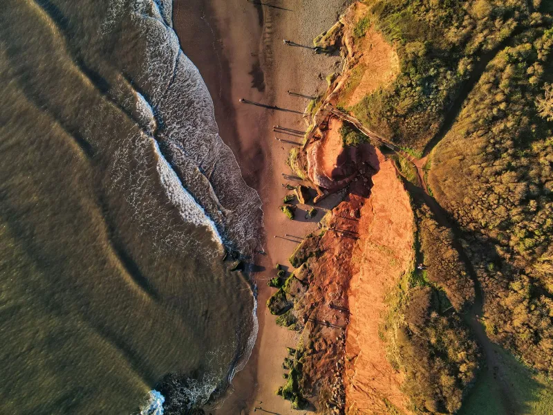
The Environment Agency's LiDAR programme has made significant progress in generating high-resolution elevation coverage across England's coastline, and equivalent work has been undertaken by Natural Resources Wales and NatureScot in the devolved nations. However, coverage is not uniform. Coastal areas that have experienced significant erosion, storm modification, or managed realignment since their last LiDAR survey may be operating on elevation data that is materially out of date. For a rapidly eroding stretch of the Holderness coast in East Yorkshire — where cliff retreat can exceed a metre per year — a survey conducted five years ago may describe a physical geography that has shifted substantially.
The refresh cycle for coastal LiDAR is constrained by cost and operational capacity. Aerial survey is expensive, and the prioritisation of limited resources inevitably means that some stretches of coast are surveyed less frequently than the rate of change would warrant. The result is a patchwork of elevation confidence, in which the planning system may not know — and may not have the tools to determine — how current its underlying topographic data actually is.
Flood Risk Geometries and the Planning Boundary Problem
Flood risk in England is formally expressed through the Environment Agency's Flood Map for Planning, which delineates Flood Zones 1, 2, and 3 across the country. These zones are the primary spatial tool through which national planning policy — as set out in the National Planning Policy Framework — directs development away from flood-prone areas and requires sequential testing where development in higher-risk zones is proposed.
The flood zone boundaries are modelled outputs, derived from hydraulic analysis that itself depends on the quality of the underlying topographic data. Where that data is coarse or outdated, the modelled boundary is correspondingly uncertain. A boundary that was accurate when it was drawn may no longer reflect the actual extent of flood risk if the coastal profile has changed through erosion, accretion, or the failure of a coastal defence structure.
Local planning authorities are expected to apply these boundaries in development management decisions, but they have limited independent capacity to assess whether a given boundary remains current. The technical complexity of coastal hydraulic modelling is beyond the resource base of most district councils, and the Environment Agency — which maintains the flood map — updates individual stretches of coastline on a rolling programme that cannot respond rapidly to localised changes.
The practical consequence is that planning decisions in some coastal communities are being made against a risk geometry that underestimates the true exposure of the land in question. Properties are approved in locations that more current modelling would place in a higher flood zone. Infrastructure is designed to standards calibrated against a flood return period that no longer captures the tail risk implied by updated climate projections.
Regional Blind Spots
The geospatial deficit is not distributed evenly around Britain's coastline. Several regions face a convergence of factors — rapid physical change, high development pressure, significant socioeconomic vulnerability, and relatively sparse monitoring infrastructure — that makes the mapping gap particularly consequential.
The Humber estuary, one of the largest in Britain, presents a complex tidal and fluvial flood environment in which the interaction between river flows, tidal surges, and managed coastal defences creates modelling challenges of considerable sophistication. Communities along the north and south banks of the Humber are subject to flood risk assessments that, whilst technically competent, rest on elevation data and defence condition surveys that are updated on timescales misaligned with the pace of climate-driven change.
On the Suffolk and Norfolk coasts, where soft cliff geology means that erosion is both rapid and unpredictable, the spatial footprint of Coastal Change Management Areas — the planning designation intended to manage development in erosion-prone zones — has not always kept pace with observed retreat rates. Properties that sat comfortably within the safe envelope when a Shoreline Management Plan was last reviewed may now sit at or beyond the projected erosion line for the current planning period.
In South Wales and the Somerset Levels, managed realignment schemes — in which coastal defences are deliberately set back to allow intertidal habitat to develop — are creating new geographies of flood exposure that existing flood maps were not designed to represent. The spatial data infrastructure for these transitional landscapes remains, in several cases, underdeveloped.
The Commercial Case for Real-Time Coastal Monitoring
Against this backdrop of institutional limitation, a growing market in commercial coastal monitoring technology is emerging. Persistent satellite radar imagery, drone-based survey, distributed sensor networks, and machine-learning-driven change detection are collectively lowering the cost of high-frequency coastal observation to a level that was not achievable a decade ago.
Several British technology firms are actively developing coastal monitoring products that combine these capabilities into operational platforms capable of delivering near-real-time shoreline change data to local authorities, port operators, and infrastructure managers. The commercial logic is straightforward: the demand for accurate, current coastal data is substantial, and the public sector's capacity to supply it through traditional survey methodologies is structurally constrained.
The governance challenge is ensuring that commercially generated coastal data is integrated into the planning and emergency response systems that need it, rather than remaining siloed within proprietary platforms accessible only to those who can afford a licence. The Geospatial Commission's National Geospatial Strategy has identified coastal resilience as a priority domain for data integration, and there is an emerging conversation — still at an early stage — about how a shared coastal data infrastructure might be funded and governed.
Planning for a Shoreline That Keeps Moving
The deeper challenge facing Britain's coastal communities is not merely technical. It is a question of institutional design: whether planning systems built around relatively static spatial designations can adapt to manage risk in an environment defined by continuous change.
The sea-level projections embedded in the UK Climate Projections 2018 dataset imply a range of future shoreline positions that span many decades and carry significant uncertainty. Planning for this range requires not a single flood zone boundary, but a probabilistic spatial framework that can express the likelihood of inundation across a spectrum of scenarios. Such frameworks exist in research settings; translating them into operational planning tools that local authorities can apply in development management decisions is a task that requires sustained investment in both technology and institutional capacity.
Britain's coastal towns are, in many cases, places of considerable economic fragility — dependent on tourism, fishing, and small-scale maritime industry, and characterised by ageing populations and constrained public finances. They are precisely the communities that can least afford to make irreversible spatial decisions on the basis of outdated maps. Getting the geospatial infrastructure right, for them, is not an abstract policy objective. It is a matter of where people will be able to live, safely, in the decades ahead.